Flash Flood Watch In Place As Winter Storm Heads Into Southern Utah
Nov 19, 2019, 5:31 AM | Updated: 5:34 am

SALT LAKE CITY, Utah – The National Weather Service issued a flash flood watch for portions of southwest Utah as a slow-moving winter storm begins to make its way to the state.
Flood watches and winter storm warnings are in effect for Washington, Iron, Kane, Garfield, Beaver and Piute counties.
KSL meteorologist Grant Weyman said southern Utah should expect heavy rains starting Tuesday evening. The storm is expected to last throughout Wednesday and Thursday.
Southern Utah looking at some HEAVY RAIN starting tonight… and some heavy snow in the mountains. Flooding will be possible tomorrow in the areas shaded in green. And snow amounts could go up to two feet. pic.twitter.com/eD7KOZ53Ur
— Grant Weyman (@KSLweyman) November 19, 2019
“Steady rainfall is expected to develop Tuesday afternoon and evening, becoming heavy at times Tuesday night through Wednesday evening,” according to the National Weather Service. “Flash flooding of slot canyons, normally dry washes, small streams and urban areas with poor drainage will be possible.”
The NWS said Utah’s Dixie and Zion National Park are especially susceptible to flash flooding, and people in those areas should be prepared to take action should a flash flood warning be issued.
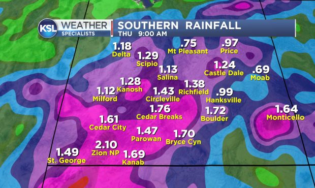
Weyman said St. George could get up to 1.49 inches of rain, while nearby Zion National Park could see 2.10 inches.
A winter weather advisory is in place for central and northeast portions of the state. Along the Wasatch Front, the storm is expected to arrive Wednesday, bringing rain and some snow through Thursday.
According to KSLweather.com, things will start to dry up for the weekend, although the highs will stay in the mid 40s.