Flash Flood Strikes Southern Utah, Zion National Park
Jun 29, 2021, 5:49 PM | Updated: Jul 5, 2023, 12:49 pm
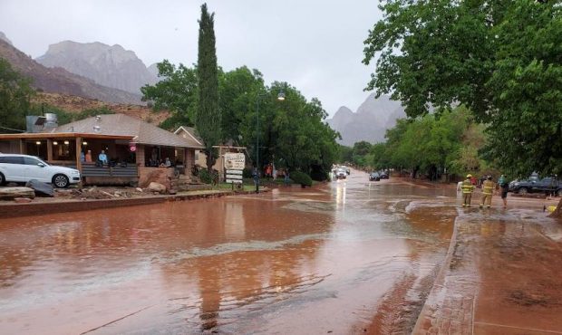
Major flooding in Springdale forced the closure of state Route 9. (UDOT Region Four/Twitter)
(UDOT Region Four/Twitter)

SPRINGDALE, Utah — Flash flooding in parts of southern Utah has sent water rushing into homes, forcing road closures and leaving drivers stranded.
Zion National Park & Springdale
Video showed large amounts of water flowing through Zion National Park Tuesday afternoon.
SR-9 has reopened between Rockville and Springdale. Zion National Park remains closed. Motorists in this area should use caution and be aware of the latest weather advisories. UDOT continues to monitor road conditions. Crews will resume further clean-up on Wednesday. https://t.co/XIqivGMyK8
— UDOT Region Four (@UDOTRegionFour) June 30, 2021
In a press release, Zion National Park officials say it rained over an inch in an hour.
Zion National Park Flash Flood Update: Due to flash flood SR-9 is currently closed, please avoid area. More information will be provided when available. https://t.co/EH4OKN9kyx pic.twitter.com/zPiYaUXatJ
— Zion National Park (@ZionNPS) June 30, 2021
As of 7:52 p.m., State Route 9 into the park was closed to inbound traffic. They say that’s due to an “active technical Search and Rescue operation.” Previously, park officials said SR-9 was shut down due to a mudslide.
Tuesday 6/29 at 3:46pm – SR-9 through Zion is currently closed until further notice due to a mudslide. Road crews are working now.
— Zion National Park (@ZionNPS) June 29, 2021
In a most recent update, officials say park staff are actively working to remove road debris. They say traffic is currently being diverted out of the park at both the South and East Entrances.
As of 6:53 p.m., SR-9 has reopened between Rockville and Springdale.
The water also rushed past buildings in Springdale, a town located just outside Zion.
Washington County officials said in a press release Tuesday night they are responded to the heavy rainfall and flash flooding in and around Zion National Park, particularly in the communities of Rockville and Springdale.
They say the ground is exceptionally dry because of the ongoing drought, meaning the ground could not absorb the heavy rain that fell in parts of the county, causing the flash flooding and run-off.
County Commissioner Victor Iverson is quoted in the press release as saying, in part, “This is how we do things in Washington County. We share resources and assist our communities however we can.”
Hildale & Colorado City
Flooding has also hit the communities of Hildale, Utah and Colorado City, Arizona.
So far, no injuries have been reported and everyone has been accounted for, but several homes have flooded, according to Mark Gower with the Colorado City Marshal’s Office.
Look at all this water flowing from the thunderstorm that just went through the Colorado City and Hildale area. pic.twitter.com/jY3q9KrU68
— Alex Cabrero (@KSL_AlexCabrero) June 29, 2021
“Turn Around, Don’t Drown. Most flood deaths occur when someone tries to drive through a flooded river, stream, or low lying area,” read a tweet from the Utah Division of Emergency Management.
Flash Flood Warning for Kane and Washington Counties. Turn Around, Don't Drown. Most flood deaths occur when someone tries to drive through a flooded river, stream, or low lying area. This photo, courtesy of UDOT, was taken earlier in Springdale. https://t.co/5iildjnin3 pic.twitter.com/zCKI3NbF9F
— Utah Division of Emergency Management (Utah DEM) (@UtahEmergency) June 29, 2021
Escalante
The Garfield County Sheriff’s Office said Tuesday evening it had to use a helicopter to rescue two people hiking in a slot canyon in the Escalante area when a flash flood hit.
Both people were able to get to higher ground where the helicopter crew was able to lift them to safety.
Kane County
A Flash Flood warning expired in Kane County at 7:45 p.m. Tuesday.
Officials with the National Weather Service said the warning was for the Lower Paria Canyon, Buckskin Gulch and the Wire Pass area.
This Flash Flood Warning is for the Lower Paria Canyon, Buckskin Gulch, and the Wire Pass area. Radar estimates 0,5-1" of rain has fallen. Take precautions if you are in this area! #utwx https://t.co/d6C8CYNRi6
— NWS Salt Lake City (@NWSSaltLakeCity) June 29, 2021
It was issued after the Kane County and San Juan County areas were hit with a severe thunderstorm warning.
Wednesday Forecast
Tuesday evening, the National Weather Service said in a tweet to expect more thunderstorms Wednesday. It said that would mean protentional flooding, including on roadways and in slot canyons. They say flash flooding in “probable” in all five of Utah’s National Parks, as well as in Glen Canyon National Recreation Area, Grand Staircase-Escalante National Monument, Natural Bridge National Monument, and Grand Gulch. The “probable” rating means that some slot canyons, dry washes, and small streams are expected to experience flash flooding.
6/30 – Shower and thunderstorm development is expected for your Wednesday. This would mean the potential for flooding impacts, including on roads and in slot canyons. Isolated storms look to stretch into N UT tomorrow, in addition to the threat across central and S UT. #utwx pic.twitter.com/aFQhrrF8Sr
— NWS Salt Lake City (@NWSSaltLakeCity) June 29, 2021