Parts Of Utah Under Flash Flood Watches, Red Flag Warnings As Storms Roll In
Aug 17, 2021, 11:02 AM | Updated: 11:04 am
(Grant Weyman/KSL TV)
(Grant Weyman/KSL TV)
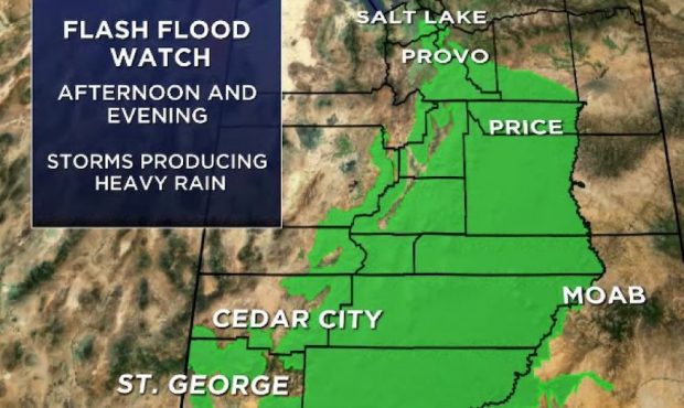
SALT LAKE CITY — Large portions of central and southern Utah will be under a flash flood watch Tuesday while the northern half of the state will also see critical fire weather as severe weather moves into the Beehive State.
The southern Wasatch Front and northeastern Utah could see over 1″ of rain by the end of the week, according to KSL meteorologist Grany Weyman.
Cooler temperatures will follow the storms, which will also help clear wildfire smoke that has lingered over the state.
Look at rain amounts possible by Friday pic.twitter.com/spALf73THl
— Grant Weyman (@KSLweyman) August 17, 2021
The main threats with Tuesday’s storms are heavy rain, strong winds and possible hail.
Flash Flood Watch
The National Weather Service said a flash flood watch will go into effect at noon Tuesday, with meteorologists keeping an eye on slot canyons, normally dry washes and burn scars.
*UPDATED* The Storm Prediction Center has elevated portions of Utah to a slight risk for severe weather (severe > marginal) this afternoon and evening.
Main threats:
⛈️Large hail
⛈️Strong winds
⛈️Heavy Rain #utwx pic.twitter.com/tsIuXlLcba— NWS Salt Lake City (@NWSSaltLakeCity) August 17, 2021
The watch was extended Tuesday morning to include Zion National Park and Washington County, along with Summit and Duchesne counties.
Burn scars will be the primary concern for northern Utah as slow-moving storms hit the area.
This flash flood watch lasts through Wednesday night.
*UPDATED* The Flash Flood Watch in effect Noon-Weds Night is expanded to include Zion National Park, Washington, Summit, and Duchesne Counties. The threat will largely be limited to flood prone areas such as burn scars, dry washes, slot canyons, and steep-sided roadways #utwx pic.twitter.com/yu5E9UhzEe
— NWS Salt Lake City (@NWSSaltLakeCity) August 17, 2021
Red Flag Warning
Before the rain arrives, a red flag warning will be in effect from the Utah-Nevada state line to the Wasatch Front, extending south toward Interstate 70.
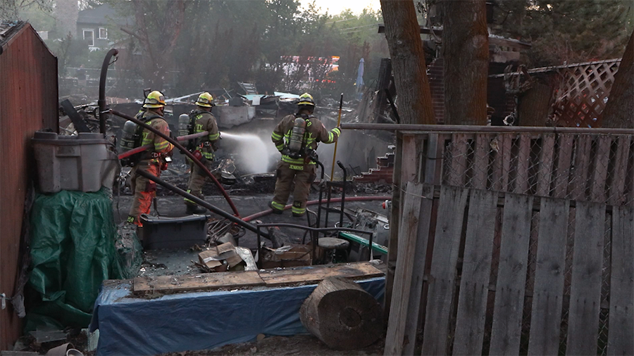
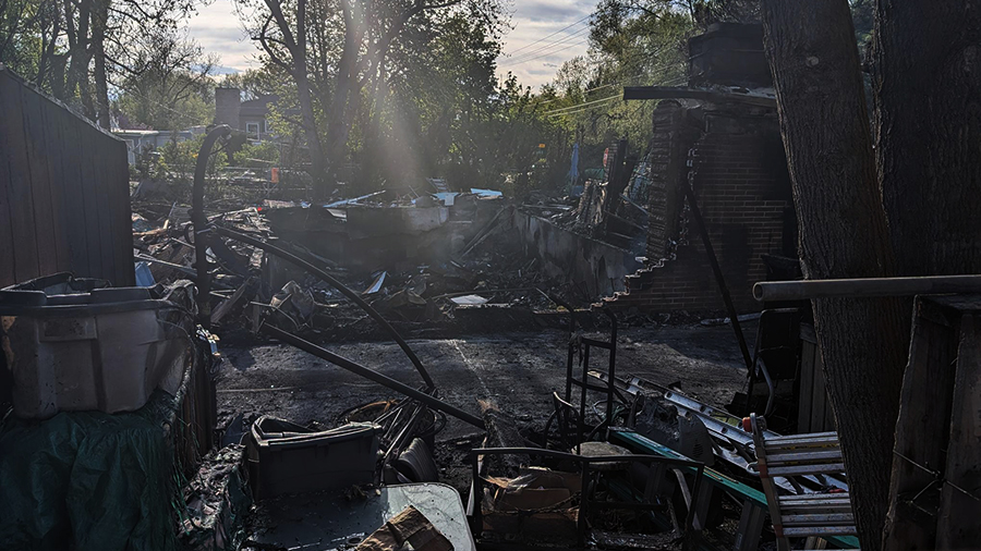
Forecasted gusty winds, thunderstorms and large hail could lead to rapid fire growth or extreme fire behavior. These conditions could lead to new lightning-caused fires and potential fire growth — a concern the Park City Fire District expressed as crews continue to battle the Parleys Canyon Fire.
First on deck for Tues: thunderstorms after a long stretch (approx. 2 weeks) of dry weather across portions of the forecast area will create critical fire weather conditions. A Red Flag Warning has been issued in these areas for 12PM – 9PM Tuesday. #utwx pic.twitter.com/sorWSgipLv
— NWS Salt Lake City (@NWSSaltLakeCity) August 16, 2021
State fire officials said the blaze had burned 541 acres and was 21% contained as of Tuesday morning. Residents of Summit Park, upper Pinebrook and Lambs Canyon are all under mandatory evacuation orders, which may last through Thursday.
Water runoff is a possibility along burn scars if significant rain occurs.