Winter weather advisory issued for much of Utah; temperatures to drop into teens, single digits
Dec 27, 2021, 9:46 AM
(UDOT)
(UDOT)
SALT LAKE CITY — A winter weather advisory will go into effect ahead of Monday’s evening commute for northern Utah while snow is expected to impact driving conditions in central and southern Utah Tuesday morning.
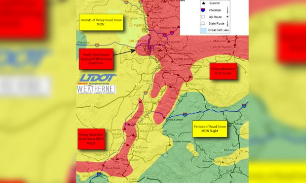
Meteorologists say a strong cold front will pass through northern Utah between 4 and 7 p.m. Monday, leading to winter road conditions in many mountain passes and travel impacts across the Wasatch Front.
The Utah Department of Transportation expects heavy road snow Monday evening on Interstate 15 between the Point of the Mountain and Davis County, I-80 between state Route 36 in Tooele County to the Utah-Wyoming border, U.S. Highway 6 between I-15 and Price and U.S. Highway 40 from Summit County to near Duchesne.
Road Weather Alert: Heavy mountain road snow and heavy valley road snow during the Monday evening commute is expected; valid 6AM Monday through 6AM Tuesday. For more info visit: https://t.co/wyBKivQhj0@UtahTrucking #utwx #utsnow pic.twitter.com/Q5R7bXrnoJ
— UDOT Traffic (@UDOTTRAFFIC) December 27, 2021
Update: Winter Weather Advisories for Monday afternoon into early Tuesday have been expanded to include:
1) Sanpete Valley
2) Bryce Canyon Country
3) South Central Utah pic.twitter.com/kM0XGyJKOy— NWS Salt Lake City (@NWSSaltLakeCity) December 27, 2021
Heavy impacts are expected in southern Utah as the snow moves south after 5 p.m. through Tuesday morning.
Snow will gradually increase across northern Utah through the day Monday, and valleys could see between 2″ and 5″ of snow. Wind gusts of up to 40 mph are also possible with this cold front.
“There is some potential for additional lake and terrain enhanced snow Monday night into early Tuesday morning, that could result in locally higher totals, especially on the benches,” meteorologists said.
The approaching storm system will bring accumulating snow to lower Washington county tonight into Tuesday. While accumulations in St. George will be light and confined to grassy surfaces, higher elevation suburbs could see up to three inches of snow. #utwx pic.twitter.com/XmwNgEvsiu
— NWS Salt Lake City (@NWSSaltLakeCity) December 27, 2021
Mountains could see an additional 1′ to 3′ of snow, with Zion National Park expecting 4″ to 8″ of snow, especially near the Zion-Mount Carmel Tunnel on S.R. 9.
Even St. George is expected to see some snow sticking on grassy areas, while higher elevation areas of Washington County could see up to 3″ of snow.
A backcountry avalanche warning has been issued for several parts of Utah through Tuesday morning.
The Utah Avalanche Center has issued a Backcountry Avalanche Warning through 6 AM Tuesday for many mountain locations across Utah. Be safe out there and check https://t.co/7cuDMdRCUO before heading out in the backcountry. #utwx https://t.co/aDA6pRhXhz
— NWS Salt Lake City (@NWSSaltLakeCity) December 27, 2021
Temperatures dropping
Temperatures across Utah will dip into the teens or single digits overnight into Tuesday.
Meteorologists expect temperatures in Logan to drop to 3 degrees while Randolph may drop into the negative.
Single digits are expected in the Uintah Basin and between Nephi and Price.
Aside from snow, did we mention it is going to get COLD? Here are the lows we are expecting Tuesday morning. Bundle up! #utwx #wywx pic.twitter.com/xlsHlpHbOj
— NWS Salt Lake City (@NWSSaltLakeCity) December 27, 2021