Researchers hope new snowpack funding data will bring valuable drought insight
Apr 6, 2022, 9:57 PM | Updated: Jun 20, 2022, 12:47 pm
SALT LAKE CITY – In the midst of a drought, few things are as important as understanding Utah’s greatest source of water, the snowpack. Two University of Utah professors just received $7 million in federal funding to broaden their research of Utah’s snowpack. They will use new technology to get a better picture of that precious resource.
As much is 80% of the water Utahns use comes from the snowpack, which melts each spring, flows into streams, and then into reservoirs.
The grant from the National Oceanic and Atmospheric Administration (NOAA) should help NOAA better forecast how mountain snowpack contributes to our water supply. The scientists aim to develop more accurate methods of measuring and analyzing our mountain snowpack.
“We are really excited to be collaborators and part of this effort,” said McKenzie Skiles, an assistant professor of geography at the University of Utah.
She and Carlos Oroza, an assistant professor of civil and environmental engineering, have collaborated on snowpack studies before. But, never with this much funding, or five years to work on it.
“So, this opens up a lot of avenues for snow hydrology research,” Skiles said.
They will incorporate new technology to generate more data on the snowpack.
“To identify what will improve our water forecasts, and our understanding of water quality and water availability,” Skiles said.
The Utah Snow Survey, operated by the Natural Resources Conservation Service, already gathers data on depth of snowpack, and snow water equivalent at multiple remote mountain sites, and transmits that data.

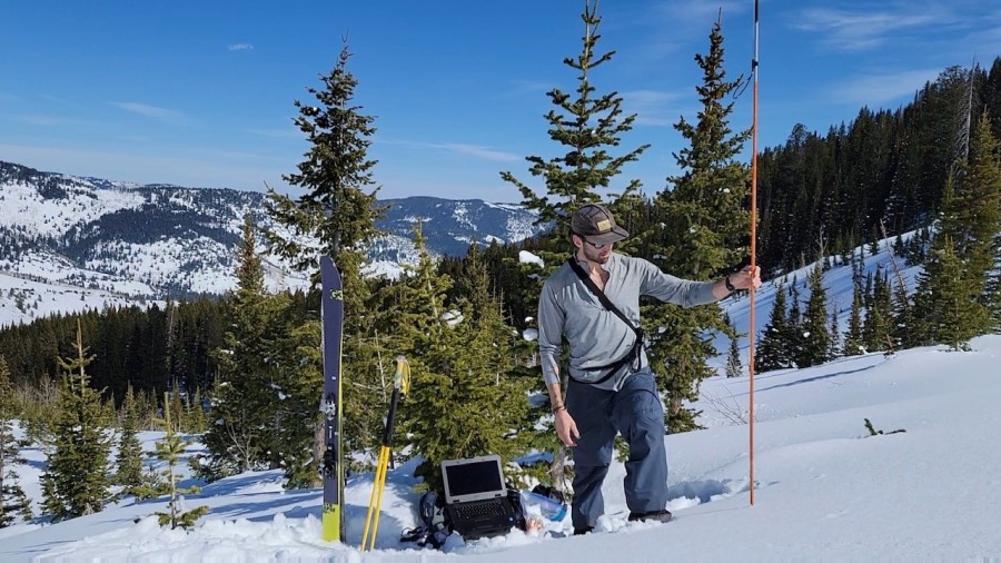
University of Utah PhD student (Dane Liljestrand) collecting a snow depth sample with his avalanche probe. The sample is GPS located with his smartphone and uploaded to the web. In the background is a computer running an algorithm researchers developed. The algorithm tells him where he needs to sample to get the most information about the snow depth, while also guiding him away from avalanche risk.
(Photo used with permission: Patrick Strong)
“That data set is long-term and is incredibly valuable,” Skiles said. “But, it only samples a small portion of the mountains.”
The new research will add aerial maps of the whole mountain through LiDAR technology, literally giving them a bigger picture of the snowpack.
“Snow depth over entire watersheds rather than just points. We’ll see maps of snow depths and water equivalent, and also estimates of timing of when that water will be available for use down stream,” Skiles said.
Right now, they don’t know how much water there is at the very highest elevations, above existing sites. LiDAR mapping gives them the ability to measure that.
“It allows us to see what’s going on right now, and we don’t really have that capability yet,” she said.
They will also enlist backcountry skiers to help them in their research. Both of the researchers themselves are backcountry skiers, as are some of their other colleagues.
“They all carry something known as an avalanche probe with them,” Skiles said. “So, they can take it out and measure the snow depth where they are skiing, and upload it to a citizen science website.”
That gives them even more points of measurement across the snowpack of Utah.
“We are really filling in the gaps between the current observation network,” the researcher said.
The University of Utah and their work will be part of a new consortium of 28 non-profit organizations, government and industry members, and partners that will research water resources and develop more accurate models for predicting catastrophic flooding.
Utah State University and Brigham Young University are also part of that consortium. The larger project will examine not only drought, but also flooding, and water quality.


