Winter weather, strong winds moving into Utah
Apr 11, 2022, 10:18 AM | Updated: Jun 29, 2022, 1:36 pm
FILE (Stuart Johnson/KSL TV)
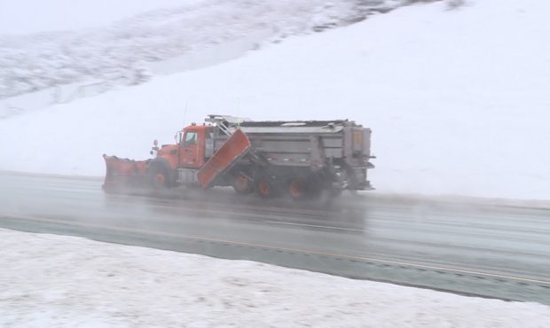
(Stuart Johnson/KSL TV)
SALT LAKE CITY — A spring storm will bring some much-needed snow to Utah’s mountains, while most of the state will see cold temperatures and strong winds, beginning Monday.
Rain will develop across northern Utah Monday evening and move south through the night and into Tuesday. Meteorologists expect valley showers to turn to snow overnight, with the most significant valley snow falling Monday night.
Winter weather warning
Northern Utah mountains could see up to 20″ of snow with this storm, with higher amounts expected in the Cottonwoods. Meteorologists say the heaviest snowfall is expected Monday night, and the warning lasts through 3 a.m. Wednesday.
Valleys could see 1″ to 3″ of snow, and snowfall could impact road conditions across the state into Tuesday.

“By Tuesday, (it’s) all snow, all the way down the I-15 corridor, all the way to eastern Utah,” said KSL Chief Meteorologist Kevin Eubank. “Then, a secondary little push comes down Tuesday afternoon and evening, and that keeps stuff going — even lake effect snow going all the way through Wednesday morning.”
High wind warnings for southern Utah
Sustained winds are expected to reach 20-30 mph across the southern half of the state Monday, with gusts reaching 50 mph or even 65 mph in some areas.
The strongest winds are expected to hit Juab, Sanpete and Carbon counties southward Monday afternoon.
Meteorologists said winds will be gusty but lighter in the northern half of the state.
Expect a windy Monday, particularly throughout southern Utah. Winds will increase out of the southwest through the morning, reaching sustained speeds of 20-30 mph in the afternoon with gusts over 50 mph. Winds will be gusty, but lighter further north. #utwx #wywx pic.twitter.com/3yZqU7GF0T
— NWS Salt Lake City (@NWSSaltLakeCity) April 10, 2022
“Gusty winds could blow around unsecured objects. A few power outages are possible. Travel will be difficult due to strong crosswinds, especially for high-profile vehicles and vehicles with trailers. Expect rough conditions on area lakes,” read the high wind advisory for southern Utah.
Cold temperatures
If you have vulnerable fruit trees, plants and other early agriculture, here are the probabilities you will see 32 or below temperatures Tuesday through Thursday. #utwx pic.twitter.com/zKMfinvSCd
— NWS Salt Lake City (@NWSSaltLakeCity) April 10, 2022
After being in the 70s Monday, southern Utah will dip into the low 50s on Tuesday, with overnights lows approaching freezing.
Northern Utah will see lows in the 30s and 20s through Wednesday, with highs struggling to reach 40 degrees on Tuesday and Wednesday.
Things warm up later this week, but temperatures will remain well below average.