Extremely critical fire conditions return to the Southwest and tornadoes threaten the Central Plains
Apr 29, 2022, 6:32 AM | Updated: Jun 8, 2022, 3:16 pm
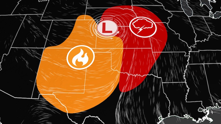
A strong storm system moving through the Rockies and Plains will whip up winds, raising worries of more fires in the Southwest and tornadoes on the Great Plains. (CNN Weather)
(CNN Weather)
(CNN) — A strong storm system moving Friday through the Rockies and Plains will whip up winds, raising worries of more fires in the Southwest and tornadoes on the Great Plains.
With the West in the grips of one of the worst droughts in decades, the fire season has not only started early, but has been setting records.
Since January, over 1 million acres have burned, well above the year-to-date average of around 632,000 acres. New Mexico has been especially hit hard with 5 large fires currently burning and the next couple of days provide no change in the forecast.
New Mexico has already reached its annual fire activity and it’s only April.
“Our season started earlier than in the past,” says Andrew Church, a National Weather Service (NWS) meteorologist with the Albuquerque office.
“Because of climate change and the mega-drought across the western U.S., there’s just no moisture in the soil anymore,” he goes on to say.
This lack of soil moisture, high temperatures and strong winds are main factors that will lead to existing fires and new ones to spread uncontrollably.
Critical fire threat increases to extreme today
Red flag warnings have been issued as winds will be whipping in some of the driest air yet, particularly in Kansas, Colorado and New Mexico. Friday’s fire danger will rise to a level 3 of 3 “extremely critical” range as conditions worsen.
The level 3 encompasses portions of southeast Colorado, including the city of Pueblo.
“Winds in this area are expected to be sustained at 30 to 40 mph with gusts up to 55 mph,” says the Storm Prediction Center.
“We’ve already had three days at the extreme level this year and were a bit concerned about this one. We’ve had multiple fires so far this year,” says Kyle Mozley, a meteorologist with NWS in Pueblo.
“Any fire that does start will have the ability to spread rapidly and that includes throwing cigarette butts out to campfires to down power lines and things like that, that would be another fear,” Mozley says.
“Along with this ‘extreme’ concern, we cannot dismiss the expanded ‘critical’ area which covers portions of five states (NM, CO, TX, OK and KS) and includes Albuquerque, Colorado Springs, Lubbock, Amarillo and Midland, Texas,” the Storm Prediction Center said. “Dry, windy conditions in the region will be at the top of the critical threshold, near extreme critical criteria.”
Current major fires they are monitoring include the Tunnel Fire in Arizona at 19,075 acres and 89% containment along with the Hermits Peak/Calf Canyon Fire in New Mexico which is at 63,720 acres and 33% containment.
Hard to believe but the drought gets worse
The U.S. Drought Monitor brought more bad news on Thursday. The Southwest and southern Plains saw further drought intensification in the last week.
“Deterioration was common across the Southwest, with extreme to exceptional drought (the two highest designations) broadly expanding in New Mexico and moderate to severe drought increasing in coverage across parts of Arizona and Colorado,” the drought summary said.
New Mexico doubled the area covered by exceptional drought (the highest level) — now covering over 15% of the state. Drought in the state has steadily intensified since the beginning of the year with nearly 68% of the state now in extreme to exceptional drought.
“It looks like it’s going to get worse before it gets better,” says Church. “We used to see relative humidity go up behind the cold fronts, but with the soil moisture completely depleted, the air stays dry with single-digit relative humidity and leads to these fire threats.”
He continues, “we might have to wait quite a while until the monsoon rains kick in, hopefully sometime in late June.”
Rain to the east, but that comes with another threat
It’s a different kind of threat in the Plains on Friday. As needed rains miss the West and Southwest, thunderstorms could become violent in the Plains with severe weather elements such as damaging winds, large hail and even tornadoes, as a potent storm tracks from the Rockies eastward.
The Storm Prediction Center has a level 3 of 5 risk across portions of Oklahoma, Kansas and Nebraska, including Tulsa, Wichita, and Lincoln, where the tornado threat will be highest.
The severe storms are expected to be most active into the afternoon and evening hours.
Meteorologist Ray Sondag with the NWS in Tulsa told CNN he expects the worst time to be between 6 p.m. and midnight.
“If we get a dryline setting up, which we think we will, these thunderstorms will move into southeast Oklahoma and could produce tennis ball-size hail along with 70 mph winds and a few tornadoes.”
On Saturday, Midwestern cities St. Louis, Chicago and Indianapolis will see the threat of severe storms.
The-CNN-Wire
™ & © 2022 Cable News Network, Inc., a WarnerMedia Company. All rights reserved.