Flood watch over popular Utah recreation areas Sunday
Jun 26, 2022, 11:37 AM | Updated: Feb 14, 2023, 4:14 pm
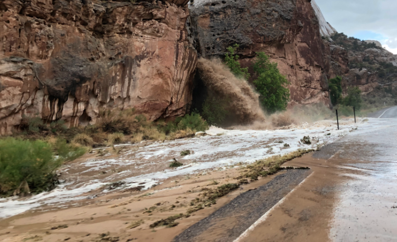
Utah's state Route 24 on June 23, 2022. (NPS)
(NPS)

UTAH — A flood watch is in effect over central southern Utah, from noon through Sunday night, as thunderstorms create potentially deadly conditions.
The flood watch includes many areas were Utahns and visitors to the state spend weekend recreation time including national parks, Lake Powell and state parks. The NWS Salt Lake office said the flash floods are most likely to develop in slot canyons, normally dry washes and areas near recent wildfire burn scars.
Thinking of heading down Cottonwood Road, Skutumpah Road, House Rock Road and other backcountry roads across southern Utah today? Check in with rangers for current conditions and NEVER cross flooded roads. #utwx
— NWS Salt Lake City (@NWSSaltLakeCity) June 26, 2022
NWS advises hikers and those with outdoor plans to monitor weather and consider alternate plans. The agency also consistently warns motorists never to cross flooded roads urging instead to “turn around, don’t drown.” Flooded roads can be fatal.
Search and rescue volunteers with the Iron Country Sheriff’s office spent Saturday working with residents and county officials to fill sand bags and prepare for possible flooding. Rains could fall on eastern and southern Utah more this week.
The flood watch is in some of Utah’s most used recreation areas including:
- Zion National Park
- San Rafael Swell
- Capitol Reef National Park and its vicinity
- Grand Staircase-Escalante National Monument
- Western Canyonlands
- Glen Canyon Recreational Area / Lake Powell
It also includes the cities of: Big Water, Bullfrog, Escalante, Goblin Valley, Green River, Hanksville, Kanab, Loa, Springdale and Torrey.
NWS said those living in areas prone to flooding should be prepared to take action.
1:35 pm – Here’s a look at the updated Radar this afternoon. We are primarily noting building thunderstorms east of I-15 and east and south of I-70 near Fremont Junction. #UTwx pic.twitter.com/HscCkCoOzC
— NWS Salt Lake City (@NWSSaltLakeCity) June 26, 2022
In addition, much of the eastern part of Utah is also under a hazardous weather outlook because of widespread showers and storms.
NWS said about the hazardous weather outlook for Sunday:
…widespread showers and storms are expected this afternoon and evening, especially across the San Juan mountains and the adjacent valleys. Periods of heavy rain, gusty outflow winds and frequent lightning are possible within any stronger storms. Showers and storms likely linger well into the overnight hours across the southern third of eastern Utah and western Colorado before diminishing towards daybreak Monday morning.
You can get the latest from NWS at: weather.gov/slc/.