High winds, heavy snow warning for ‘hazardous conditions’ Friday morning
Dec 1, 2022, 4:25 PM | Updated: 10:28 pm

SALT LAKE CITY — The National Weather Service’s Salt Lake office has issued warning for a winter snow storm and high winds throughout Utah effective Thursday evening and Friday morning.
The cold front is expected to bring several inches of snow and high speed winds overnight, effecting the Friday morning commute.
Winds began Thursday morning, clocking gusts up to 95 mph along the Little Cottonwood ridge line.
Wow! Impressive wind speeds along the Little Cottonwood ridgeline this morning and elsewhere across the Wasatch. 95 mph Hidden Peak, 80 mph on Baldy, and Big Cottonwood with 57 mph on Reynolds Peak. #utwx pic.twitter.com/BwrVRLOkyq
— NWS Salt Lake City (@NWSSaltLakeCity) December 1, 2022
The wind warning is in effect now until 1 a.m. Friday, with winds coming from the south at 25-65 mph near the Great Salt Lake desert and mountains, including Tooele and rush valleys, Salt Lake Valley, western Millard and Juab counties, and southwest Utah.
Nick Wall, Tooele City Emergency Management said it has been really windy since last night with gusts continuing throughout the day.
“We’ve had several calls, five calls today related to power lines, we had a power pole involved that knocked out power to 1,300 customers,: Wall said. “It’s been really windy as you can tell.”
Ahead of the storm Wall encouraged people to secure outdoor furniture and other items.
“They should take care of their yards, take care of their properties, makes sure any lose items are taken care of, garbage cans, trampolines, just doing the small things around the house so major things don’t happen,” Wall said.
These powerful winds may blow around objects and cause power outages, and will contribute to travel difficulties in the morning.
The winter storm warning is in effect from 11 p.m. Thursday to 11 a.m. Friday, with heavy snow fall and high winds during commute hours Friday morning for most mountain routes across Utah, NWS said.
When the front comes through Utah, NWS expects heavy snow in Northern Utah at 2 a.m., heaviest until 7 a.m., and it will progress south bringing heavy snow to Southern Utah between 5 and 10 a.m..
Depending on location, the NWS anticipates heavy snowfall to last 1-2 hours at their peak in most areas, with 6 – 12 inches of snow throughout the central and southern mountains and the Wasatch Plateau.
The NWS said to plan on slippery road conditions and low visibility for a “hazardous” commute. Though snow may be done falling especially in northern Utah during the morning commute, they said snow will still be on the roads.
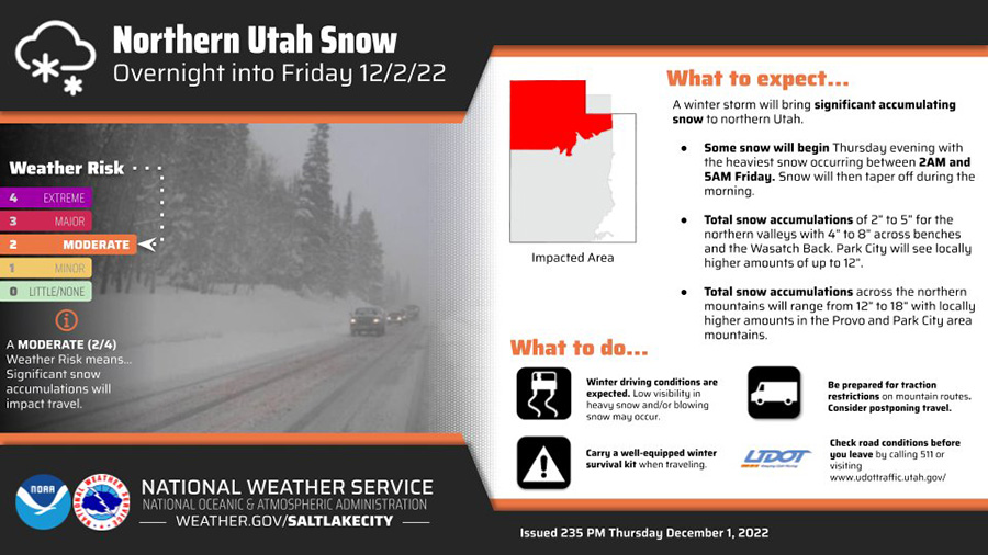
For northern Utah valleys to experience heavy snow Friday morning. NWS said to delay travel if possible. (National Weather Service)
Southwest Wyoming is expected to see significant snowfall as well, with its peak between 3 and 7 a.m..
The NWS advises travelers to be prepared for an emergency with equipment like flashlights, food and water, a blanket, and checking road conditions in advance.