Winter storm warning and weather advisory consumes Utah
Jan 1, 2023, 12:12 PM | Updated: 1:22 pm
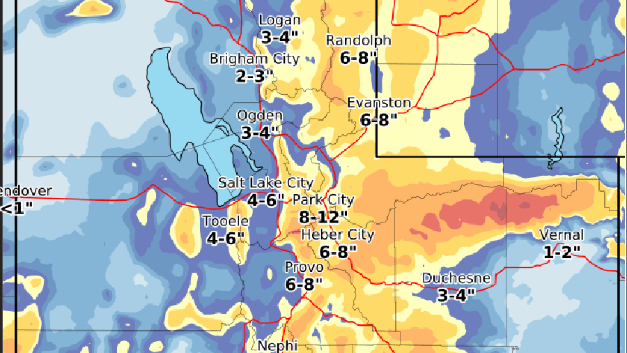
The NWS issued several winter storm warnings and released this map forecasting snow accumulation expected to come from the storm New Years Day. (National Weather Service Salt Lake City)
(National Weather Service Salt Lake City)
SALT LAKE CITY — The National Weather Service has issued several winter storm warnings and winter weather advisories that cover the state New Year’s Day.
Flash flood warning
A flash flood warning was issued for areas in Southern Utah including Iron, Kane, and Washington counties. This warning is in effect until 2:15 p.m. Sunday, and follows park ranger’s reports of heavy rainfall and canyon flooding at Zion National Park.
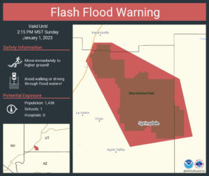
A flash flood warning map shows the areas that may be at risk of flash flooding New Years Day. (National Weather Service Salt Lake City)
Avalanche dangers
Avalanches are also posing a threat, as Little Cottonwood Canyon remains closed for avalanche mitigation.
🚧#RoadClosureUpdate🚧
👋 LCC travelers, #SR210 still CLOSED. @UDOTavy avalanche mitigation is ongoing. Please be patient while road & avalanche crews work.No estimated opening time – update provided when known.@UDOTTRAFFIC @AltaCentral @AltaAlerts @SnowbirdAlerts @UPDSL pic.twitter.com/esnJarpVpX
— UDOT Cottonwood Canyons (@UDOTcottonwoods) January 1, 2023
Avalanche risks on Sunday are extreme in Provo, and high risk in several areas including Logan, Ogden, Uintas, Salt Lake, Skyline, Moab, Southwest Utah.
Heavy snow
The winter weather advisories cover most of the state, with winter storm warnings in major areas across the Wasatch Front and Wasatch Back, causing snowy driving conditions on roads and highways effective until 5 a.m. Monday.
On New Year’s Day morning, a carport covered in heavy snow in West Jordan collapsed on to 14 cars.
NWS anticipates deep snow accumulations:
- 6-12 inches of snow around Park City
- 1-3 feet of snow in Wasatch Mountains, western Uintas, Provo Canyon, and Upper Cottonwoods
- 4-8 inches in northern Utah cities including Brigham City, Logan, Snowville, and Smithfield
- 1-2 feet near Brian Head and Pine Valley
- 6-12 inches in Bear Lake and Bear River valleys, Garden City
Other areas have warnings in effect past Monday morning.
Northwest San Juan Mountains are expected to see 10-20 inches until 6 p.m. Monday.
Eastern Uintas may see 1-2 feet of snow through Noon Monday
Road conditions
The NWS anticipates winter driving conditions to make travel very difficult to impossible in many areas, depending on the time rain changes to snow. “Regardless, the snow will result in difficult travel conditions as it falls,” the warning states.
UDOT has also sent warnings about winter driving conditions, anticipating slick roads to last through Monday at 10 a.m. affecting those who will be commuting.
Road Weather Alert:
Wintry road conditions are expected across much of the state through Monday morning, including continued snow in the Salt Lake Valley.
Valid: Through 10 AM Monday
For more information, visit: https://t.co/4P1gO2c9Uo#utwx #utsnow @UtahTrucking pic.twitter.com/IzOo6fF0Yb
— UDOT Traffic (@UDOTTRAFFIC) January 1, 2023
Sgt. Brian Peterson of UHP said speed is the number one cause of crashes on slick roads.
“Posted speeds are for dry/ideal conditions. Slow down for wet, snowy, slushy, icy roads,” he said.
He recommends avoiding cruise control and hard braking, as well as increasing stopping distance when traveling in winter conditions.
Correcting a skid:
- Steer into a slide. If the back end slides to the right, steer right
- Avoid hard and unnecessary braking – braking could make the slide worse
- Don’t panic and overcorrect
- Maintain a safe speed
If you crash:
- Move to the right to get out of traffic.
- Stay in your car with your seatbelt on, just in case you are hit again. A pedestrian is much more vulnerable.
- If there are no injuries and your cars are moveable, move off the freeway and call the police.
You can see more about winter road conditions from the Utah Department of Transportation or you can call 511.


