Scattered Storms Moving Across Utah; Flash Flooding Possible Along Burn Scars
Jul 27, 2021, 11:40 AM | Updated: 11:44 am
(National Weather Service/Twitter)
(National Weather Service/Twitter)
SALT LAKE CITY — Meteorologists say heavy rain from scattered thunderstorms will hit central Utah, the Wasatch Front and northern Utah Tuesday, with flash flooding possible in urban areas and along burn scars.
The National Weather Service has issued a Hazardous Weather Outlook for large parts of central and northern Utah, which begins Tuesday.
A 40% chance of showers and thunderstorms this afternoon. Some of the storms could produce heavy rain, lightning, gusty winds and flash flooding. Do not walk or drive through flood waters. Turn Around, Don’t Drown! One foot of moving water can sweep your vehicle away. pic.twitter.com/14seeVV6rK
— SLCo Emergency Mngt. (@SLCoEmerMngt) July 27, 2021
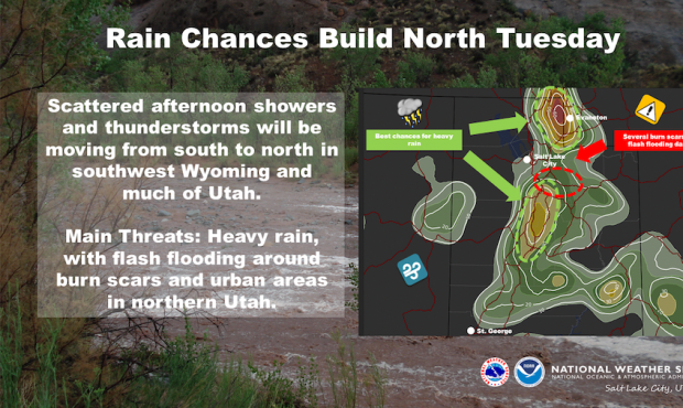
“The best chance for showers and thunderstorms will be in southwest Wyoming and northern Utah Tuesday afternoon with flash flooding a threat,” meteorologists said. “That chance is lower to the south, but isolated showers and thunderstorms are expected.”
Beginning Wednesday and lasting through Monday, “showers and thunderstorms capable of heavy rain, gusty winds and small hail will occur each afternoon and evening across much of the forecast area.”
Meteorologists highlighted the Cache Valley and northern Utah as having the highest chance for severe weather Tuesday, followed by central Utah along the I-15 corridor.
Burn scars in Utah County were also highlighted as having a heightened risk of flash flooding with Tuesday’s storms.
Last week, Mapleton issued evacuations ahead of possible flash flooding. No injuries or damages were reported but authorities reported debris flows with 6″ to 8″ of mud and basketball-sized rocks.
Iron County was hit hard Monday when 2″ of rain fell in less than an hour, flooding roads and homes in Cedar City.
Mayor Maile Wilson-Edwards declared a state of emergency and crews were assessing damages Tuesday.
Wilson-Edwards has scheduled a press conference for noon to provide an update on those clean-up efforts.