1 dead after Oklahoma tornadoes as millions in the Midwest face a strong tornado threat
May 7, 2024, 10:12 AM | Updated: 10:31 am

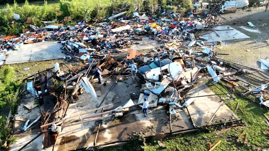
Tornado damage is seen in Barnsdall, Oklahoma, on May 7, 2024. (CNN)
(CNN)
(CNN) — Destructive storms roared through the Plains Monday, unloading at least one deadly tornado, giant hail and hurricane-force wind gusts. As some communities pick up the pieces, new ones must prepare for the threat of strong tornadoes in the Midwest.
• One dead, multiple injuries: At least one person is dead and several others are injured after a tornado tore through Oklahoma’s Osage and Washington counties Monday night, Osage County Sheriff Eddie Virden said in an on-air interview with CNN affiliate KOKI. Extensive damage occurred to dozens of homes between Barnsdall and Bartlesville and there were multiple injuries. “We did take a direct hit from a tornado here in Bartlesville,” Washington County Emergency Management Director of Operations Kary Cox said.
• Town hit by tornado for the second time in five weeks: Monday night’s tornado triggered a tornado emergency for Barnsdall, Oklahoma, but residents here were all too familiar with the situation. It was the second damaging tornado in just over a month to hit the town, which was struck by an EF1 on April 1.
• Tornado damage in at least two other states: A tornado caused “considerable damage” in Sullivan, Missouri, late Monday night according to storm reports. The extent of the damage is unclear, but images from the scene showed buildings filleted by the twister. Another tornado tore through parts of DeKalb County, Tennessee, and damaged at least a dozen homes in the Smithville area early Monday afternoon, officials told CNN.
• More than 200 storm reports: There were 244 storm reports Monday, including 17 tornado reports, according to the Storm Prediction Center. Hail the size of softballs slammed down in Kansas while baseball-sized hail pummeled Oklahoma. Wind gusts of 70 mph or greater were recorded in Nebraska and Kansas while an 82-mph wind gust occurred near Chester, Oklahoma.
• Rare high risk issued: Monday marked the first high – Level 5 of 5 – risk issued for the US by the Storm Prediction Center in more than a year. It was the first time in nearly five years Oklahoma was under such an extreme risk and the first time in nearly seven years in Kansas.
• More storms to come: Level 3 of 5 risks for severe thunderstorms are in place for parts of the US on Tuesday and Wednesday, with millions at risk of damaging wind gusts, hail and tornadoes.

Tornado damage is seen in Barnsdall, Oklahoma, on May 7, 2024. (CNN)
Tornado threat shifts to Midwest, Tennessee Valley Tuesday
Severe thunderstorms Tuesday will ramp up the threat of damaging wind gusts, large hail and tornadoes for the eastern US.
The most potent thunderstorms are likely to center on parts of the Midwest and into the Tennessee Valley from the afternoon onward.
Nearly 13 million people here are at risk of a few strong tornadoes of at least EF2 strength. The Level 3 of 5 risk area includes large portions of Indiana, including Indianapolis; Kentucky, including Louisville; and Ohio, including Columbus.
Damaging winds and hail are possible outside of the highest risk area across a huge portion of the eastern US.
Millions are at risk of damaging storms once again on Wednesday, including areas hard-hit by Monday’s storms.
An expansive Level 3 of 5 risk of severe thunderstorms is in place from northeastern Texas and eastern Oklahoma to much of Kentucky and Tennessee. Damaging wind gusts, hail bigger than baseballs and tornadoes are all possible within Wednesday’s storms.
Some strong tornadoes are possible, mainly from Missouri through central Kentucky and northern Tennessee. St. Louis and Nashville are just two cities at risk of powerful tornadoes.
Torrential rainfall may also occur within any storm Wednesday and trigger flash flooding. A Level 2 of 4 risk of excessive rainfall is in place for a large portion of the Tennessee and Ohio valleys, according to the Weather Prediction Center. Rainfall rates could approach 1 to 2 inches per hour in the heaviest storms.
Contributing: Joe Sutton and Robert Shackelford, CNN


