Utah Co. Air Quality “Unhealthy” For Sensitive Groups, Pole Creek Fire at 33 Percent Containment
Sep 22, 2018, 11:41 AM | Updated: 11:42 am

UTAH COUNTY, Utah – Fire officials battling the Pole Creek Fire sent out updated fire information this morning at 8:13 a.m.
With 33 percent containment they say they are making “significant” progress. Here is the information they released. Specific areas in bold for quick scanning.
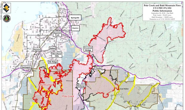
Friday was another successful day, as crews made significant progress on the Pole Creek Fire, which is now 99,693 acres and 33% contained. While both Hwy. 6 and Hwy. 89 are open, please drive carefully and be aware fire operations are ongoing along both roads. People will continue to see occasional tree torching and some fire movement, especially on the east side of Hwy. 89.
Operations and the Incident Commander flew the southeast corner of the fire near Coffee Pot Trail, as well as the ridge west of Wanrhodes, looking for opportunities to take more direct action on the fire. Crews on the east side of Wanrhodes conducted tactical firing operations to secure the line along Red Mountain Butte.
The fire continued slowly backing down the ridge above the Covered Bridge area, but crews have completed a secondary line around the subdivision. Fire crews were successful containing more line east of Diamond Fork, as well as along Hwy. 89.
Saturday, September 22, 2018
With poor humidity recovery overnight, the fire will likely become active sooner in the day. Firefighters are prepared for near more active fire behavior due to southwest winds blowing 10-15 miles per hour and gusts to 30 miles per hour. On Sunday, a Red Flag Warning will be issued due to stronger winds, with gust to 40 mph.
Priority areas for firefighters continue to be the back side of Spanish Peak, Wanrhodes Creek and Covered Bridge, as well as a portion of the southeast corner of the fire near Coffee Pot Trail where fire was active yesterday. In the Wanrhodes area, fire crews continue structure protection efforts, as well as conducting structure assessments in the Hobble Creek area.
With the terrain and predicted winds, smoke will likely be visible on the southeast corner of the fire near Coffee Pot Trail, where firefighters are looking for options to go more direct.
Air Quality Information: https://www.airnow.gov/?reportingArea=Provo&stateCode=UT
As of 11:37 a.m. – Unhealthy for sensitive groups, which was an upgrade from the red “unhealthy” warning early this morning.
Area Closures:
The Uinta-Wasatch-Cache National Forest implemented an area closure for the fire areas, until further notice. The full closure order and map can be found under the closure tab on the Pole Creek Fire InciWeb page. The area closure includes areas currently burning in the Bald Mountain Fire area.
Evacuations in the Covered Bridge and Diamond Fork areas remain in effect.
Temporary Flight Restrictions (TFR): There is a TFR over both wildfires
Fire Progression Map link: http://www.simtable.com/apps/fireProgression/output2018/UTUWF_000971_Pole_Creek.html