Winter Storm Watch Issued For Wasatch Front To Begin 2020
Dec 30, 2019, 3:43 PM | Updated: 3:46 pm
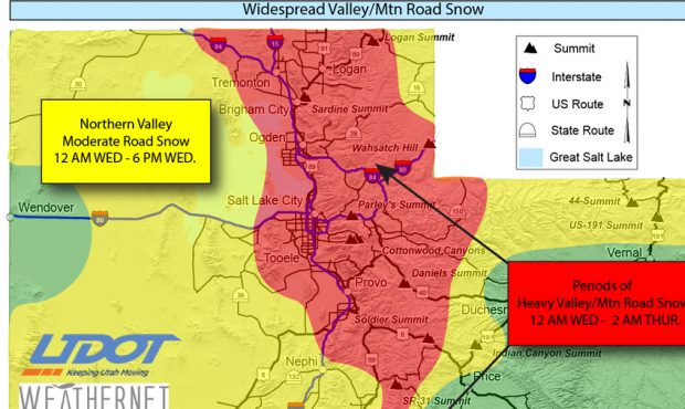
Widespread road snow is expected for much of the state, according to the Utah Department of Transportation. (UDOT/Twitter)
(UDOT/Twitter)
SALT LAKE CITY, Utah – A winter storm could cause hazardous driving conditions on New Year’s Day for the Wasatch Front from Logan to Nephi, according to officials with the Utah Department of Transportation.
Winter weather is expected to hit the Wasatch Front and parts of southwestern Utah beginning late Tuesday night through Thursday morning, according to KSL meteorologists.
A winter storm watch begins at 2 a.m. Wednesday and goes through 5 p.m. Thursday. Four-to-eight inches of snow is possible across the Wasatch Front and locally higher amounts are likely on bench locations.
UDOT officials expect periods of heavy snow to impact roads from the Utah-Idaho border to central Utah, including Interstates 15, 70, 80, 84 and 215, beginning at midnight on Jan. 1.
Moderate snow could hit I-15 from Nephi south to Cedar City, with a winter storm watch issued for mountain passes north of Beaver and east of Fillmore.
Road Weather Alert: Widespread road snow expected for much of the state WED morn through THUR Evening. For more info: https://t.co/4P1gO1U0Gg #utwx #utsnow @UtahTrucking pic.twitter.com/hxKKdrRkD1
— UDOT Traffic (@UDOTTRAFFIC) December 30, 2019
Stay up to date with the weather at KSL Weather. Watch live on KSLTV.com/live or download the KSLTV app at KSLTV.com/app. You can also get weather alerts for your specific area with the KSL Weather app. Get it on at App Store or on Google Play.