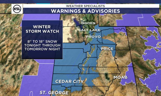
Winter storm watch in effect for Utah mountains as storm moves in
Oct 11, 2021, 10:55 AM
SALT LAKE CITY — A storm will bring rain to the Wasatch Front and snow to Utah’s mountains Monday, according to the KSL Weather team.
A winter storm watch is in effect as mountain elevations could see 8″ to 18″ of snow through Tuesday, and highs along the Wasatch Front will drop below 50 degrees.
Up to a foot and a half of snow by tomorrow in mountains pic.twitter.com/o4u8iBTh6z
— Grant Weyman (@KSLweyman) October 11, 2021
KSL meteorologists and the National Weather Service said the storm system will move in Monday afternoon, with rain beginning to fall after 4 p.m. Rain will turn into snow overnight and into Tuesday, and the benches could see some accumulation.
Wind gusts of 40 mph have already been reported along Interstate 80 between Wendover and Grantsville, and meteorologists said to expect gusty winds across southwestern Utah Monday afternoon.
Mountain passes along the I-15 corridor between Nephi and Cedar City could see winter driving conditions once the storm moves in.
A Winter Storm Watch is in effect for many mountain locations Monday evening-Tuesday. Portions of the I-15 corridor, particularly on summits between Nephi and Cedar City are expected to have winter driving conditions along with mountain routes throughout UT and WY. #utwx #wywx pic.twitter.com/BexGExhSJL
— NWS Salt Lake City (@NWSSaltLakeCity) October 10, 2021
Some scattered storms remain possible into Wednesday before things begin to dry out statewide that afternoon.
And some reminders from KSL meteorologist Grant Weyman — make sure to winterize your sprinkler systems and detach hoses, check your furnaces (temperatures will drop into the 30s this week) and make sure your tires are ready for wet and possibly icy road conditions.
— Grant Weyman (@KSLweyman) October 11, 2021