WEATHER ALERT: Potentially damaging and dangerous winds to blow into Wasatch Front
Mar 13, 2024, 3:50 PM | Updated: Mar 14, 2024, 7:21 pm
SALT LAKE CITY — The KSL Weather team warns that potentially dangerous and damaging winds are expected to blow across the northern Wasatch Front on Thursday and Friday.
KSL TV meteorologist Matt Johnson said a cold front is going to drop to southern Utah on the Nevada border and as it does, it will bring powerful winds to the Wasatch Front.
“That wind will come racing down the Wasatch mountains. From Bountiful northward, that’s where the strongest winds will be (Thursday) into Friday,” he said.
🚨EAST WIND EVENT TOMORROW 🚨 pic.twitter.com/YMhc23VMUj
— Matthew Johnson (@KSL_Matt) March 14, 2024
The National Weather Service office in Salt Lake City said strong winds will occur on U.S. Highway 89, Interstate 15 and Legacy Parkway in northern Salt Lake County and Davis and Weber counties. Travelers were advised to be prepared for possible closures or vehicle restrictions.
Eastern Box Elder County and Cache Valley were also expecting powerful winds.
“Be prepared for airborne debris and difficult travel conditions,” NWS said. “Power outages may impact traffic signals.”
KSL’s Devan Masciulli suggested charging devices ahead of possible power outages and advised securing loose outdoor items in areas prone to high winds. Like Johnson, she advised gusts could blow as hard as 85 mph. NWS issued a high wind warning from 9 a.m. Thursday through noon Friday.
Some power outages were considered likely and residents were advised to secure outdoor objects such as decorations, garbage cans, umbrellas and trampolines to avoid property damage.
⚠Attention! NOW is the time to prepare for dangerous downslope winds if you live in prone areas…including portions of the N. Wasatch Front, Cache Valley, and areas E of Price.
See the following thread for more information on timing, impacts, and how to prepare. ⬇(1/5) #utwx pic.twitter.com/oCPnU120Ad
— NWS Salt Lake City (@NWSSaltLakeCity) March 13, 2024
Johnson said winds will develop late Thursday morning into the afternoon and will last into Friday morning, then taper off Friday afternoon.
A high wind warning, which goes into effect at 9 a.m. Thursday, called for strong down-sloping winds along the Wasatch Front – especially the canyon mouths. “NOW is the time to prepare for dangerous portions of the N. Wasatch Front, Cache Valley, and areas E of Price,” a weather service tweet stated.
Winds in some places will be powerful enough to down trees, damage property and tip high-profile vehicles and vehicles with trailers. The Utah Department of Transportation warned of possible road closures.
Johnson said valley gusts could reach 60-70 mph and mountain gusts would be even stronger at 80-90 mph.
Rocky Mountain Power was preparing for possible outages. Wednesday the utility cautioned its customers to treat all downed wires as live and dangerous.
If you see damaged power lines do not go near them and contact Rocky Mountain Power here.
More snow for southern Utah
A low-pressure system behind Tuesday’s precipitation is moving across Utah on Wednesday; however, it is forecast to shift course by late Wednesday or early Thursday as it moves through the state, shifting to the southwest, toward Las Vegas.
Various alerts are tied to different impacts expected as the low-pressure system moves toward the southwest. It’ll bring precipitation from the south to parts of southern Utah, primarily on Thursday and Friday.
A winter storm warning was issued for the southern, central, Abajo and La Sal mountain ranges. It states accumulations of 10 to 20 inches are possible by Saturday morning in southeast Utah’s mountains, while 6 to 16 inches of snow is possible for most parts of the central and southern Utah ranges.
Some places could end up with much higher totals.
Wednesday morning a storm brought snow to many parts of Utah. Saratoga Springs saw nearly an inch of snow. Several mountain areas received as much as 16 inches.
Information on snow totals from the Wasatch Front and mountain areas is included below.
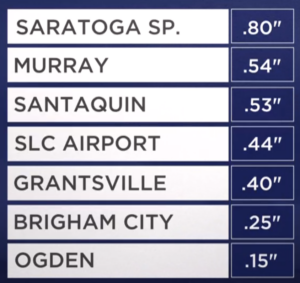
(Matt Johnson, KSL TV)
You can get a look at ski area and other mountain area snow totals here.

