Devastating tornadoes flatten homes in Nebraska and Iowa as storm threat grows ‘dangerous’ for millions
Apr 27, 2024, 3:08 PM
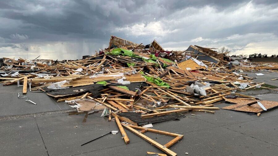
Debris is seen from a destroyed home northwest of Omaha, Nebraska, after a storm tore through the area on April 26. (Margery A. Beck/AP via CNN Newsource)
(Margery A. Beck/AP via CNN Newsource)
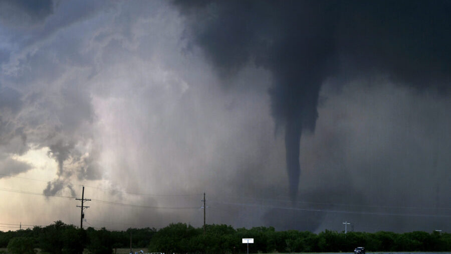
(CNN) — Destructive tornadoes gutted homes as they plowed through Nebraska and Iowa, and the “dangerous” weather threat escalated significantly on Saturday as tornado-spawning storms posed a risk from Michigan to Texas.
The area of Elkhorn in Omaha, Nebraska, is one of the hardest-hit communities after severe storms barreled through parts of the Plains and South early Friday afternoon, authorities said. A powerful tornado leveled homes, which crews searched for anyone trapped or injured, local authorities said.
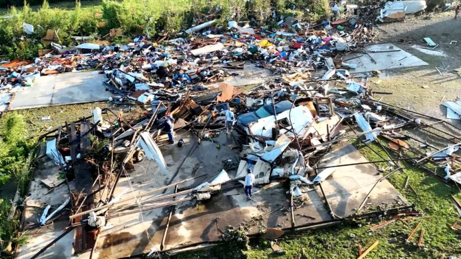
Meanwhile in nearby Iowa, a large tornado was reported in the small city of Minden, according to the National Weather Service. Footage obtained by CNN shows the devastation of mangled structures and widespread debris.
The severe weather threat is expected to continue through Sunday, with Saturday possibly being the most dangerous day. Strong tornadoes are possible from Nebraska to Texas, including Dallas, Austin, Oklahoma City, Tulsa, Kansas City and Wichita.
A rare Particularly Dangerous Situation tornado watch affecting nearly 2 million people was issued, in effect until 8 p.m. local time Saturday. It includes Enid, Oklahoma, Wichita Falls, Texas, Oklahoma City and its western suburbs, and the city of Norman. The counties of Cleveland, McClain, Oklahoma, Payne, Garvin, Jefferson and Stephens were added Saturday afternoon.
Such tornado watches are issued when there is high confidence of multiple strong or violent tornadoes, according to the Storm Prediction Center. Supercells with large hail and damaging winds are expected, with the most intense producing strong or potentially long-tracked tornadoes.
A tornado watch – affecting 1.5 million people – was issued by the storm center earlier Saturday across eastern Kansas and southeastern Nebraska, including the cities of Topeka and Wichita. The watch includes threats of a few tornadoes and a couple intense twisters, widespread large hail and damaging wind gusts up to 75 mph until 7 p.m. local time.
A third tornado watch was later issued for parts of Kansas, Iowa and Missouri, in effect until 9 p.m. local time. It includes St. Joseph, Missouri, and suburbs outside of Kansas City, Missouri, and Des Moines, Iowa. The latest watch brought the total affected population to nearly 4 million people.
Millions could be impacted
And 18 million people across Nebraska, Iowa, Kansas, Missouri, Oklahoma and Texas are under flood watches through Sunday afternoon, according to the National Weather Service. Long-track destructive tornadoes and heavy rain are expected, with the worst of the storms during the evening and overnight on Saturday.
The national Weather Prediction Center warned of a rare “high risk for excessive rain and flash flooding” event for a small area east of Oklahoma City. It warned of more than 3 to 6 inches of rain in the high-risk area, with the possibility of exceeding 1 to 2 inches an hour.
The warning included high confidence in a major flash flood event in parts of east-central Oklahoma, with higher end rainfall totals beginning late Saturday evening.
Here’s the latest
• Four people in Iowa’s Pottawattamie County suffered storm-related injuries and received medical treatment, county emergency management officials said in a news release early Saturday.
• Roughly 120 homes and businesses were damaged in Pottawattamie County, where Minden is located and the home of about 90,000 residents. “Preliminary information indicates varying degrees of damage,” emergency officials said.
•Omaha’s Eppley Airfield reopened for aircraft operations Saturday but delays were expected, city officials said. The passenger terminal was not affected by the storm, but damage assessments at the airport were ongoing.
• Two people in Omaha received medical treatment for minor injuries after a tornado swept through the Elkhorn area Friday. “We think injuries were so little because the warning systems in the City of Omaha and Douglas County were highly effective,” Omaha Police Chief Todd Schmaderer said. “We were not hit with a sudden storm. People had warned of this, which saved lives.”
• Emergency officials in Nebraska’s Shelby and Douglas counties said there were no reports of serious injuries there after several tornadoes hit their communities Friday. However, the officials reported the storms inflicted significant property damage, and residents have been displaced.
• On the outskirts of Lincoln, Nebraska, a tornado tore the roofs off homes and crossed part of I-80 as it cut through. Multiple cars of a train derailed near Waverly after it was struck by a tornado, according to a railway spokesperson.
• In response to the tornado that tore through Minden, Iowa Gov. Kim Reynolds issued a disaster proclamation to support storm recovery efforts in Pottawattamie County.
• At least two tornadoes were observed in Texas on Friday afternoon. Video posted to social media showed an apparent twister churning across a large field northeast of Waco.
• There were nearly 80 tornado reports Friday across at least five states, many of which have been confirmed by the weather service or through footage from storm chasers.
‘We’re thankful to be alive’
Jason Sunday, a resident of hard-hit Elkhorn in Omaha, described the tornado as a “freight train.” As it approached, he sought cover in his home, which he had just moved into 30 days ago, CNN affiliate KETV reported.
“We saw it coming from the southwest, and when it got too close for comfort, we headed downstairs quickly. We were in the downstairs bathtub, and it was just like the movie said, it was like a freight train,” Sunday told CNN affiliate KETV.
“And you knew the roof was coming off because that was a loud pop and sucking motion. It was pretty scary.”
The tornado caused severe damage to the Sunday family’s dream home.
“We’re thankful to be alive. We’re very thankful,” Sunday added.
John Wells, a cleanup volunteer in the town of Blair just north of Omaha, says he saw sprawling storm damage Friday.
“There’s propane tanks that are flipped. There’s houses that they’re not even on their foundation. You don’t even know where they were,” he told KETV. “I’ve never seen anything like this.”
What to expect Saturday
More than 50 million people are under the threat of severe weather Saturday from the Southern Plains into the Great Lakes region.
“A complex but potentially significant severe weather episode is expected on Saturday,” the Weather Prediction Center said Friday.
The most significant storms are possible starting in the afternoon in parts of the southern and central Plains, where a Level 4 of 5 risk of severe thunderstorms is in place. Widespread damaging wind gusts, hail up to the size of baseballs and strong tornadoes are the storms’ main hazards.
“Several strong tornadoes will be likely, and a few long-track EF3+ tornadoes (winds between 136 and 165 mph) will be possible,” the Storm Prediction Center said.
The tornado threat could ramp up considerably through the late afternoon and evening hours with “multiple strong tornadoes” possible, according to the prediction center.
Damaging storms are possible outside of the greatest risk area in a huge area of the country from the Great Lakes to southern Texas.
Rain could also be a culprit Saturday.
Some areas could see nearly 5 inches of rain in a short period and dangerous flash flooding could result. A handful of locations caught under multiple rounds of gushing rainfall could have totals approach the 8-inch mark.
A Level 3 of 4 risk of excessive rainfall is in place for a large portion of Oklahoma – including Oklahoma City and Tulsa – and smaller parts of Kansas and Texas. Intense rainfall could force streams to overflow their banks and flood roadways.
Sunday could still see storms
Damaging storms also are possible from Texas to Wisconsin Sunday. But the exact timing, extent and strength of these storms will depend heavily on Saturday night’s storms.
Notably, areas from northeastern Texas to southern Iowa and western Illinois face the greatest chance for damaging storms that could bring strong wind gusts and large hail. An isolated tornado or two is also possible.
Heavy, flooding rainfall is possible, especially in parts of the Lower Mississippi Valley.

