WEATHER ALERT: Utah resorts delay openings as avalanche danger remains high
Jan 10, 2024, 10:45 PM | Updated: Jan 15, 2024, 1:56 pm

To keep up with weather as it happens, the KSL Weather Team will have the latest information on air. You can stream KSL TV news on the KSL+ app with news and replay forecasts. And, as always, the KSL Weather app is available for weather info near you.
MONDAY, 1:45 p.m. — Snowbird announced its opening to a limited number of ski lifts as avalanche mitigation was still underway.
View this post on Instagram
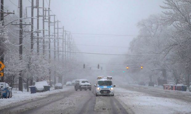
MONDAY, 11:45 a.m. — The road to Little Cottonwood Canyon, state Route 210, reopened at approximately 10:30 a.m. on Monday. The traction law was additionally lifted for Big and Little Cottonwood canyons. However, the Utah Avalanche Center warned that avalanche danger is still extremely high.
These are perfect conditions across the state for an avalanche accident. The storm has
departed, but the danger has not. With clearing skies, backcountry riders hungry for the
Greatest Snow on Earth will continue to find dangerous avalanche conditions. Most avalanche
accidents and fatalities occur after peak instability when the danger is not Extreme, but at High
or Considerable. Tree-snapping and life threatening avalanches 2-4’ deep and hundreds of feet
wide are luring travelers well out onto the slope before avalanching. It should be emphasized
that avalanches are occurring in unusual areas, such as lower elevation terrain, which may
impact snowshoers or dog walkers.
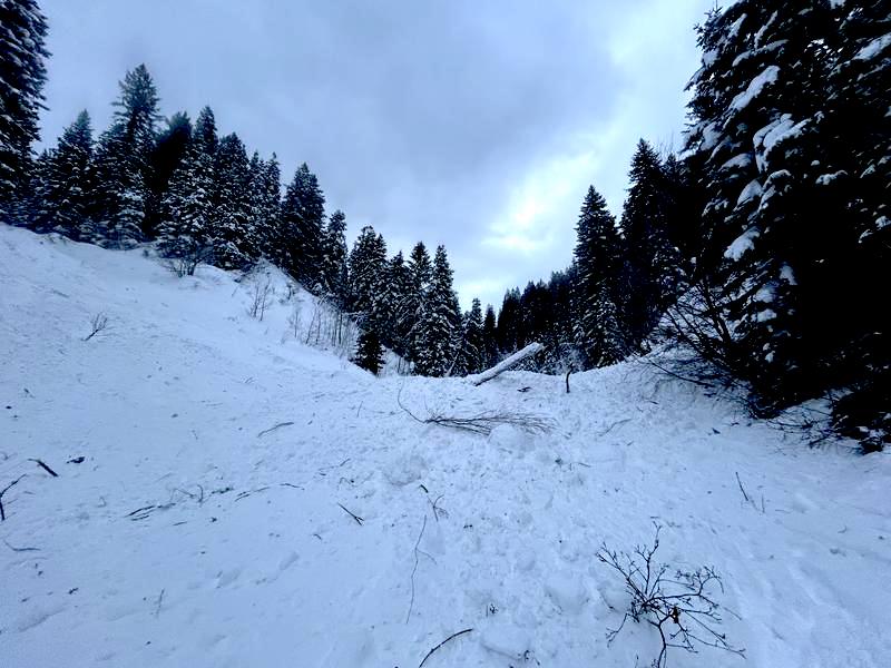
A large avalanche debris pile from Sunday that crossed Millcreek Road on the groomed trail above a closed gate. The UAC issued a warning stating avalanches are occurring in unusual areas and lower elevation terrain. (JW Hall, Utah Avalanche Center)
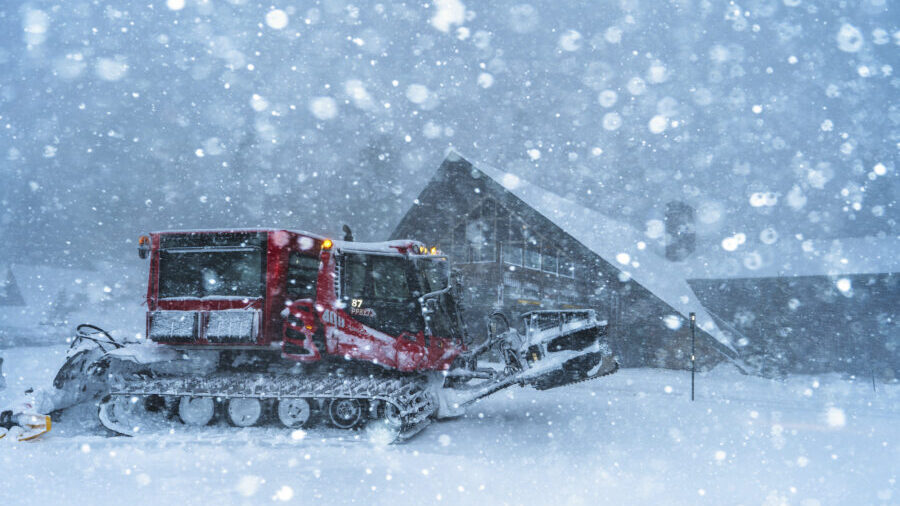
After staying in interlodge for most of Sunday, Alta and Snowbird resorts have lifted the restriction. However, due to high winds and continued avalanche danger, the resorts were slow to open on Monday.
- Snowbird is closed to mountain access because lifts are delayed due to high winds.
- Alta ski lifts are opening slowly and partial access to the mountain is available.
- Deer Valley Resort announced that due to high winds, they will also be delayed in opening and have not yet provided an update.
- Nordic Valley Resort is closed due to a fire that damaged one of its buildings Monday morning.
Small snow showers are projected by KSL meteorologist Matthew Johnson to linger on Monday for a few hours, but he said they will not stay for long. The remainder of Monday and Tuesday is estimated to be dry.
Johnson said most of the Utah Valley picked up anywhere from 2 to 6 inches over the weekend.
SUNDAY, 6 p.m. — Little Cottonwood Canyon will reopen at approximately 10 a.m. on Monday, according to the Utah Department of Transportation.
UDOT is asking anyone who is planning to go to the Alta or Snowbird resorts to not block traffic for the Cottonwood Heights or Sandy neighborhoods.
“If the queue is long, it may take you a while to even get moving once the road opens,” UDOT posted on X.
🚧#SR210 CLOSED: ETO 10am (1/15)
‼️Uphill travel delays and fully stopped traffic are possible when road is reopened.
‼️If the queue is long, it may take you a while to even get moving once the road opens.
🚨Traction devices currently required. pic.twitter.com/5SUYLWhFRb
— UDOT Cottonwood Canyons (@UDOTcottonwoods) January 15, 2024
UDOT also said the north side of Little Cottonwood Canyon’s backcountry is closed from 4 p.m. Sunday to 10 a.m. Sunday. The City of Alta is in interlodge and the Snowbird Village will go into interlodge at 9 p.m. Sunday.
- U.S. 189 at mile marker 8 in Provo Canyon
- SR92 on the Alpine Loop northbound from mile marker 27 (just off Provo Canyon Road) to mile marker 22 for avalanche control.
- SR92 on the Alpine Loop at mile marker 8, near the canyon entrance from Highland in both directions.
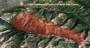
- SR210, access to Little Cottonwood Canyon, is fully closed until further notice.
- SR158, with access to Powder Mountain, has reopened.
- SR143, with access to Brian Head, is closed at mile marker 17.
SUNDAY, 1:40 p.m. — Little Cottonwood Canyon will not be open at all on Sunday due to avalanche mitigation and cleanup, according to the Utah Department of Transportation.
🚧 #RoadClosureUpdate 🚧#SR210 CLOSED: WILL NOT OPEN TODAY@UtahDOT avalanche mitigation & road operations continues. Slides crossed road in multiple areas, debris clean up ongoing.@UDOTavy continues to assess hazard.
‼️NO ETO at this time – update provided when available. pic.twitter.com/YEzM3C8SfS
— UDOT Cottonwood Canyons (@UDOTcottonwoods) January 14, 2024
SUNDAY, 12:45 p.m. — According to the Utah Department of Transportation, the following roads were closed for weather as of 12:40 p.m. Sunday.
- U.S. 189 at mile marker 8 in Provo Canyon
- Utah state Route 92 on the Alpine Loop northbound from mile marker 27 (just off Provo Canyon Road) to mile marker 22 for avalanche control.
- Utah state Route 92 on the Alpine Loop at mile marker 8, near the canyon entrance from Highland in both directions.
- Utah state Route 210, access to Little Cottonwood Canyon, is fully closed until further notice.
- Utah state Route 158, with access to Powder Mountain is closed until further notice, at mile marker 7
- Utah state route 143, with access to Brian Head is closed at mile marker 17
SUNDAY a.m. — A winter storm continues to bring heavy mountain snow and is expected to do so through at least Sunday night. Utah Avalanche Center describes avalanche conditions as “extraordinarily dangerous” from Logan in the north to Fairview in central Utah. Those conditions are rated as extreme, the organization’s highest rating.
Mountains near Moab have a “considerable” avalanche rating.
“We are moving towards maximum security interlodge restrictions for the town of Alta,” a city public safety account stated at 9:30 a.m. Sunday.
UDOT reported that the path up Little Cottonwood Canyon, state Route 210, remains closed with no estimated opening.
🚧 #RoadClosureUpdate 🚧
👋 #SR210 REMAINS CLOSED: @UtahDOT avalanche mitigation & road operations continues, large results are occurring throughout canyon. @UDOTavy working thoroughly & methodically in all sections.‼️NO ETO at this time – will provide update when available. pic.twitter.com/qi2GJqODzk
— UDOT Cottonwood Canyons (@UDOTcottonwoods) January 14, 2024
Power Mountain will not open Sunday after reporting more than 14 inches of heavy snow overnight on top of 66 inches of lighter snow over the last six days. Natural avalanches have cover the road and UDOT is not opening state Route 158. The resort’s snow safety team has decided to keep the resort closed.
A winter storm is still bringing heavy mountain snow and will continue to bring it through Sunday night according to the KSL Weather Team.
THE AVALANCHE DANGER IS EXTREME, EXTRAORDINARILY DANGEROUS AVALANCHE CONDITIONS. NATURAL AND HUMAN-TRIGGERED AVALANCHES ARE CERTAIN. AVOID ALL AVALANCHE TERRAIN.
DEADLY AND DANGEROUS AVALANCHE CONDITIONS EXIST ON ALL ASPECTS AND ELEVATIONS. pic.twitter.com/W2nCULbIlh
— UtahAvalancheCenter (@UACwasatch) January 14, 2024
Warmer air is present in valleys bringing a mix of rain and snow. It is believed valley locations south of Ogden will be more likely see mainly rain, before colder air moves in Sunday. This will mean some accumulating snow, though totals will likely be lower for the areas with rain at around 1 to 2 inches.
Colder locations, like mountain benches and north of Ogden, could see 3 to 6 inches of snow. Northern mountains could pick up another foot and a half of snow. Models show showers wind down overnight Sunday with more dry conditions Monday.
NWS has a winter storm warning that continues Monday for the cities of Alta, Brighton, Cove Fort, Fish Lake, Indian Canyon, Joes Valley, Mirror Lake Highway, Moon Lake and Scofield.
Canyons could still see significant snow through Monday afternoon. Mountain travel could be perilous.
Snowbird reports 17 inches of snow overnight as of 6 a.m. Sunday, giving the resort more than 5 feet of snow in the last seven days.
“Deadly and dangerous avalanche conditions exist on all aspects and elevations,” Utah Avalanche Center stated at 8 a.m.
SATURDAY 4:30 p.m. – A Winter Storm Warning remains in effect until until Monday at 5 a.m. for much of the state. Portions of northern Utah, including northern Wasatch Front could receive an additional 4 to 10 inches of snow, according to the KSL Weather Team.
Snow may mix to rain in parts of Weber and Davis counties late Saturday night into Sunday morning. It expected to turn back to all snow by Sunday afternoon.
In parts of Utah County, an additional 2 to 5 inches of snow can be expected through Monday morning.
If you must travel during this conditions, you are encouraged to keep an extra flash light, food and water in your vehicle in case of an emergency.
SATURDAY 11 a.m. – State Route 210 in Little Cottonwood Canyon has reopened Saturday morning, but several other freeways and highways are still under weather watch.
According to the Utah Department of Transportation, SR-210 was reopened around 9:40 a.m. after avalanche mitigation operations in the canyon. However, UDOT says to expect travel delays to Snowbird and Alta throughout the morning.
UDOT also warns visitors to Little Cottonwood Canyon that the canyon may close early Saturday night due to another round of snowstorms. UDOT suggests leaving before 3 p.m. or you might be stuck in the canyon for the night.
Alta said it has lifted its interlodge alert.
❄️#SR210
More snow is forecasted today. Keep this in mind for your PM commute and planning your downhill departures, lest you want to be stuck in canyon late tonight.‼️ Consider an early departure (before 3pm). pic.twitter.com/OddYKMpq1V
— UDOT Cottonwood Canyons (@UDOTcottonwoods) January 13, 2024
Utah Highway Patrol plans to close Provo and American Fork Canyons late Saturday night due to the upcoming winter conditions hitting the area.
UHP says the closure will start for eastbound traffic at 800 North and for westbound traffic at the midway off-ramp. The closure will begin at 10 p.m. Saturday and will last to 12 p.m. Sunday.
Here is a list of other major closures that are in effect for the rest of the state:
- SR-143 in Iron County; Both directions.
- HWY-89 & HWY-36 in Bear Lake County, Idaho.
Here is a list of reopened roads:
- US-40, from Fruitland to Heber.
- US-89 in Logan Canyon.
- SR-158 in Weber County: Both directions.
FRIDAY, 9 p.m. – State Route 191 at Indian Canyon will be closed until Saturday morning until 6 a.m. due to winter weather, according to Utah Highway Patrol.
UHP also said state Route 40 is experiencing extreme winter road conditions from mileposts 40 to 58 and asks travelers to avoid the area until conditions improve.
Please be advised SR-191 at Indian Canyon will be closed until January 13th at 6:00 am due winter road conditions. pic.twitter.com/V3lV9ENtaG
— Utah Highway Patrol (@UTHighwayPatrol) January 13, 2024
FRIDAY, 5 p.m. — State Route 210, the only road up and down in Little Cottonwood Canyon, will close at 12:30 a.m. Saturday for safety as the first of two weekend storms hit, according to Utah Department of Transportation.
The city of Alta, at the top of the canyon, will go into interlodge at 1 a.m., meaning people will be required to stay inside buildings during avalanche mitigation. It is estimated the interlodge will end at 8:30 a.m. Saturday. Snowbird, also in the canyon, has not announced an interlodge at press time, but asked patrons for patience in during avalanche mitigation on its social media platforms.
UDOT said Little Cottonwood Canyon backcountry will close tonight at 10 p.m. from Gate B to Twin Lakes pass and is anticipated to open at 8:30 Saturday morning.
Little Cottonwood Canyon backcountry will close at 10 p.m. Friday, Jan. 12, to 8:30 a.m. Jan. 13. (UDOT)
FRIDAY, 3 p.m. — The Ogden Divide, a high mountain pass in Weber Canyon will be closed through Monday according to Utah Department of Transportation spokesman John Gleason.
Indian Canyon, that carries traffic on U.S. Route 191 is also closed according to traffic officials. Several semis pulled over on the road because they weren’t able to safely navigate it winter conditions.
UDOT identified the road challenges it anticipates Friday. It listed roads it expects to be impacted:
- I-80, MM 50 to Wyoming border
- I-15, Idaho border to Beaver
- I-70, Salina and Clear Creek Summits
- I-84, Entire route
- I-215, Entire route
- US-89, Idaho border to Manti
- US-189, Entire route
- US-191, Wyoming border through US-191 Summit; Through Indian Canyon Summit to US-6 Junction
- US-40, Entire route
- US-50, Scipio to Salina
- US-6, Lynndyl to I-15; Spanish Fork to Helper
- SR-190 Big Cottonwood, Entire route
- SR-210 Little Cottonwood, Entire route
- SR-16, Entire route
- SR-30, Entire route
- SR-31, Entire route
- SR-35, Entire route
- SR-39, Entire route
- SR-20, Summit
- SR-44, Entire route
- SR-150, Entire route
- SR-158, Entire route
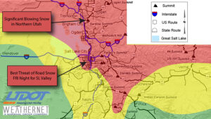
Utah Department of Transportation mapped its traffic concerns starting Friday. (UDOT)
FRIDAY, noon — The KSL Weather team said Friday is a tease for a weekend of snow to come. Mountains continue to get snow, making roads and passes problematic. Travel there will require caution and preparation.
Friday evening snow will hit most north of Salt Lake City that could create travel challenges. Later Friday the storms should sag to the south bringing snow to Utah Valley and Tooele Valley overnight.
Later Saturday heavier snow is expected and more snow moves into the Wasatch Front and will continue through the day and Sunday evening.
Total Friday accumulations will mean a 1 to 3 inches on Friday with Saturday and Sunday bring 4 to 9 inches additional inches of valley snow. Mountain totals will be much greater, possibly to bring canyon closures and avalanche danger.
WEEKEND STORM:
TODAY: PM snow showers mainly SLC north. 1-3″ some locations capable of more.
SATURDAY: Increasing snow for afternoon/evening, heaviest overnight. 2-3″ (freezing line may cause brief rain/snow at night)
SUNDAY: Periods of snow especially in the AM. 2-6″#utwx pic.twitter.com/nEjOdsQmK8
— Matthew Johnson (@KSL_Matt) January 12, 2024
FRIDAY, 8 a.m. — Avalanches closed parts of the North Ogden Divide in Weber County and Logan Canyon, while crews have reopened Little Cottonwood Canyon after avalanche mitigation work.
Powder Mountain and Beaver Mountain resorts announced they will not open on Friday.
Rescue crews urge outdoor enthusiasts to be prepared in the mountains
THURSDAY, 8 p.m. — Both directions of Sardine Canyon in Box Elder and Cache counties is closed because of poor road conditions in bad weather. As KSL’s Weather Team predicted, mountain snows continue with flurries in lower elevations.
THURSDAY, 4 p.m — After 1 to 3 inches along with Wasatch Front, with more in Utah Valley, we can look for possible lake-effect snow south and east of the Great Salt Lake. Northern Utah is looking at some snow showers on Friday but more substation snow on Saturday and Sunday, according to the KSL Weather Team.
SNOW LAKE CITY: Aside from Friday’s 1-2″ of snow & 20% chance for rain SAT, the weekend looks snowy.
46 of 50 members of the EURO ensemble have a grand total of at least 10″! This doesn’t guarantee that amount, but exudes high confidence that this could be big snow Sat/SUN❄️ pic.twitter.com/RMm7cOof9X
— Matthew Johnson (@KSL_Matt) January 11, 2024
SALT LAKE CITY — Wednesday saw another in a series of storms plow through northern Utah, leaving behind slick roads and rising snow totals in Utah valleys and mountains. It left difficult road conditions as it swept south.
The KSL Weather Team tracked the storm as it moved south from the top of the state and through the most populated areas by late evening, though flurries remained. Overnight the storm continued its path through Utah where it is expected to exit the state by Thursday morning and give the state a small break — for now, according to KSL meteorologist Kevin Eubank.
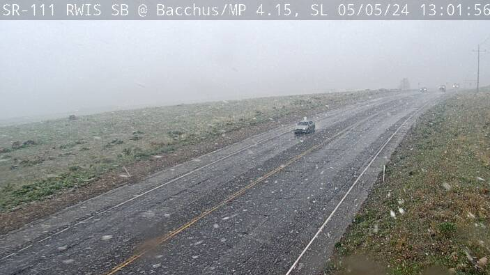
Northern Utah is into some thick weather this evening and our Lauren Steinbrecher is keeping an eye on Little Cottonwood Canyon with this look. Stay safe!#utwx #kslwx pic.twitter.com/pFfaU0dLp1
— KSL 5 TV (@KSL5TV) January 11, 2024
The storm reduced visibility, dropped temperatures and dropped snow on roads, just in time for the evening commute Wednesday. Utah Highway Patrol spokesman Sgt. Cam Roden said troopers responded to over 150 crashes Wednesday.
First responders slammed as second round of snow pounds Wasatch Front
“It just hit with a vengeance,” Eubank said. He said the timing made the snow especially tough. Snow persisted in northern Utah mountains overnight and flurries will continue, though the main front largely moves south and out of the state. On Friday, another small front will set the stage for more winter action on the weekend, for what the KSL Weather Team said is likely to be heavier snow.
Northern Utah is into some thick weather this evening and our Lauren Steinbrecher is keeping an eye on Little Cottonwood Canyon with this look. Stay safe!#utwx #kslwx pic.twitter.com/pFfaU0dLp1
— KSL 5 TV (@KSL5TV) January 11, 2024
To keep up with weather as it happens, the KSL Weather Team will have the latest information on air. You can stream KSL news on the KSL+ app to stream news and replay forecasts. And, as always, the KSL Weather app is available for weather near you.