Water watchers ‘encouraged’ that this year’s extra runoff could help Great Salt Lake rise
Mar 12, 2024, 5:45 PM | Updated: Mar 13, 2024, 9:21 am

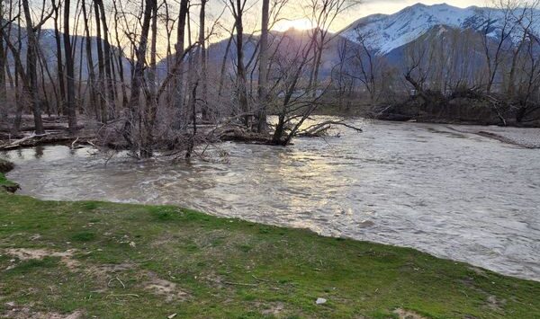
SALT LAKE CITY — Rain and snow could hit Utah overnight but even if we didn’t get another drop, the amount of water in our mountains is already above average for the year.
As of March 8, the Utah Snow Survey reports Utah’s snow water equivalent – or how much water is in our snowpack – is at about 118% on average for the state.
This, combined with last year’s record-breaking snowpack, has water watchers ‘encouraged’ about how much water must come down from the mountains.
“There is going to be a high potential for extra water carry overflow to make it to those downstream water bodies like the Great Salt Lake, like Lake Powell, and in a reasonably large and significant way,” Jordan Clayton, manager of the Utah Snow Survey, said.
The department manages 138 weather stations across Utah and Nevada and is tasked with predicting how much water will come down once the snow melts.
Clayton said that because of Mother Nature, and Utah’s management and conservation after last year’s wet winter, Utah’s reservoirs are 82% full.
“That could raise the level of the lake, you know, one to two feet above where it is right now. And so that’s pretty encouraging,” he said.
Still, Clayton was cautious about being too exact because he says there are a substantial amount of variables.
“But, we are anticipating a pretty significant (uptick) somewhere in the range of possibly 800,000 acre-feet. If we continue in the direction that we’ve gone with this winter, it could be even as high as a million-acre feet of water into the Great Salt Lake,” he said.
Clayton said that flooding wasn’t a huge concern yet, simply because this year’s snow totals aren’t record-crushing.
“And so that’s why we’re not really thinking about flooding yet. It’s going to really depend on what happens in the next month or two,” he said.
In his monthly newsletter sent out on March 1, Clayton predicts that some stream flows will be above average, while others will stay under.
“Forecasts are generally for above normal flows in northern Utah — particularly the Bear, Weber and Provo-Jordan basins — close to normal flows in central Utah, and below normal flows in southern Utah — particularly for the Sevier, Beaver and Southwestern Utah areas. Specific details are listed in each basin’s section of this Water Supply Outlook Report,” it stated.