Flash Flood Watches In Effect For Southern Utah
Jul 24, 2021, 5:36 PM | Updated: 6:28 pm
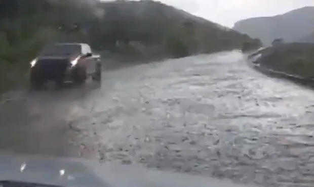
Heavy rain caused problems for motorists on SR 14 east of Cedar Crest. (Used by permission, Dustin Leslie)
(Used by permission, Dustin Leslie)

SALT LAKE CITY – The National Weather Service issued flash flood warnings across much Southern Utah Saturday afternoon.
KSL Meteorologist Kristen Van Dyke there was already localized flash flooding in some areas.
The National Park Service said heavy rain caused rock and mudslides the forced them to close all roads in Cathedral Valley as well as the Queen’s Garden Trail and the Navajo Loop. A quick closure on the road to Bryce Point had already been lifted.
UPDATE: All roads in Cathedral Valley are IMPASSABLE to most vehicles due to deep mud, down-cut washes, & flooded road sections. Road repair timing is unknown; don't make it worse by driving off road. Call 435-425-3791. Press #1 for info; #4 for road conditions
NPS photos 7-24-21 pic.twitter.com/rWm0zybCgI— Capitol Reef NPS (@CapitolReefNPS) July 24, 2021
The warnings also included Cannonville, Glendale, Hildale, and Tropic.
A warning for Gunlock is in effect until 8:30 p.m.
A severe thunderstorm is nearly stationary near the Pine Valley area with heavy rain, quarter sized hail, and 60 mph winds expected. #utwx https://t.co/QEOrPE9p1M
— NWS Salt Lake City (@NWSSaltLakeCity) July 24, 2021
A cell of storms crossing Washington County and headed towards St. George had the potential for hale and winds up to 60 miles per hour.
In addition, the National Weather Service said heavy rain and quarter-sized hail pounded the Pine Valley area earlier Saturday.
Kristen’s forecast can be seen here: