More Utah traffic impacts expected Wednesday after snow causes problems Tuesday
Jan 10, 2024, 10:08 AM | Updated: 4:28 pm
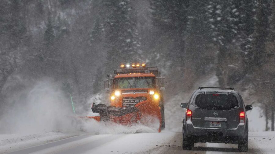
A snowplow clears the road in Big Cottonwood Canyon on Dec. 1. A third storm is expected to impact Utah this weekend, providing more snow in the valleys and mountains. (Laura Seitz, Deseret News)
(Laura Seitz, Deseret News)

SALT LAKE CITY — A second wave of snow, including another possible snow squall, is expected to arrive in Utah on Wednesday afternoon after a squall and the snowstorm behind it led to dozens of crashes Tuesday, some additional damage and even some school delays.
Another cold front Wednesday is forecast to cause “a quick round of wind, snow and low visibility at times,” said KSL meteorologist Matt Johnson. It’s expected to arrive in the Logan area sometime between 2 to 4 p.m. before reaching the Salt Lake area between 4 to 6 p.m. and the Provo area by 7 to 10 p.m. before reaching the St. George area early Thursday morning.
This may produce another snow squall warning, which the National Weather Service will alert on if that happens.
What to know about a snow squall warning by LarryDCurtis on Scribd
Its timing will likely result in similar traffic impacts as Tuesday’s storm, the Utah Department of Transportation wrote in a road weather alert issued for Wednesday.
“The main evening commute impacts will again be north of Salt Lake City,” the agency wrote. “The biggest difference from (Tuesday’s) storm is that snow is expected to be slightly heavier and it is expected to travel much further south, with impacts expected along most of I-15 by the early morning hours Thursday.”
Mountain passes are most likely to be impacted again on Wednesday. Johnson said the snow will slow down in the valleys on Thursday, but it’s expected to continue at higher elevations.
Provo City School District announced a delayed start for schools Wednesday, as Tuesday’s storm caused all sorts of problems across Utah’s northern half. Provo school officials stated “concerns about potential road conditions in the morning,” though, the school day would continue as normal and let out at normal times.
The district’s half-day kindergarten, preschool and other midday and after-school programs were canceled for the day.
“Buses may be a little bit late so we ask that you please be patient as you wait for the bus to arrive,” Provo district officials said.
Utah Highway Patrol troopers also received 77 reports of crashes by 9:30 p.m. Tuesday, expecting more to come Wednesday. A quick burst of wind from a fast-moving snow squall also toppled some trees, according to photos sent to KSL.
Mountain View Corridor at Redwood Road in Saratoga Springs was briefly shut down after some drivers became stuck in the snow late Tuesday, due to limited visibility and drifts. That portion of the highway saw the same issue on Sunday, with 40 slide-offs and crashes forcing the highway’s closure.
“That’s an area that is susceptible to these winds and the drifting snow,” UDOT spokesman John Gleason said.
Road officials urged drivers not to enter Mountain View Corridor from Redwood Road during periods of heavy snowfall.
More snow is expected to close out the week. In fact, snow is in the forecast for Friday, Saturday and Sunday as the active winter pattern continues. Johnson says the Wasatch Mountains may end up with 4 to 6 feet of new snow by the start of next week from all of these storms, while snow in the valleys during those days may cause more transportation headaches.
Full seven-day forecasts for areas across Utah can be found online, at the KSL Weather Center.
Contributing: Lauren Steinbrecher